
HAFOD Y LLAN
Craflwyn – Bylchau Terfyn – Hafod y LLan – Llyn Dinas
This fine circular walk begins from the National Trust’s Craflwyn car park. It is a moderately strenuous 10.5k hike which takes you through incredibly diverse terrain. If you don’t have the time to complete such a lengthy route, try the shorter option of climbing to the high point, Bylchau Terfyn and then retracing your steps to Craflwyn.
The exciting circular route takes you up to Bylchau Terfyn, down to the lower portion of the Watkin Path and then around Llyn Dinas. Woodland paths and waterfalls give way to open countryside before you ascend via a picturesque valley to Bylchau Terfyn. The walk down from here to the Watkin Path affords incredible views before you reach the gorgeous Cwm Llan waterfalls. You can then enjoy a leisurely stroll around the beautiful lake.
Duration: 3.5 hours with a break for lunch
Terrain: Woodland paths, rocky paths, some boggy areas

Getting Started
The trail starts behind the National Trust car park at Craflwyn and next to the information board which features surprisingly little information! One of the useful things that you won’t find here is a map of this route! To start with, follow the pink waymarkers for the Legendary Trail of Dinas Emrys. This trail will take you through woodland and past a small waterfall beside which there are stone steps leading up to gate. Keep following this route and you will arrive at a second waterfall which cascades into a pretty pool. It’s worth lingering here for a while as it is such a lovely spot. If you have the time, clamber up the hill next to the falls to see a gorgeous series of cascades tumbling down the mountainside.
Continue past the waterfall and around the corner. You will come to a point where the trail splits. The right hand fork is the Legendary Trail of Dinas Emrys. Ignore this and take the left fork which leads up into open countryside via switchbacks.
")
")
Abandoned mine
The trail climbs steadily upwards and won’t be long before you start to benefit from wonderful views of the valley and surrounding peaks. Unfortunately this section of the route has no waymarkers but the path is pretty obvious so you shouldn’t get lost. Watch out for a point by the river where the path splits again. Ignore the bridge over the river next to the derelict cottage and continue straight on through the metal gate. The path bends to left and you will see a small dam in the river. This is a nice spot for a rest and refreshments.
Continue on the trail which now does feature waymarkers. These have black arrows on white backgrounds. There are a few boggy areas to traverse and a couple of stiles. A little further on you will pass a disused copper mine which sits in an open area of the striking valley. The path then continues upwards and becomes a little steeper but nothing too challenging. If you are walking with dogs, please note that one of the stiles on this route has a dog hatch next to it, the other does not.
The High Point
Keep following the waymarkers with the black arrows. The last portion of the walk is the steepest and there are a few rocky sections which require a little clambering. But it only takes a few minutes to negotiate your way to the high point of the trail. Bylchau Terfyn delivers impressive views back down the valley and to the peaks beyond. It can get windy up there and so it isn’t the best place to stop for a picnic! If you would appreciate a rest, walk down a bit and find a nice spot to sit which is out of the breeze.
This is the point at which you must decide whether to retrace your steps or continue to the lower portion of the Watkin Path and then back to the car park via LLyn Dinas. Either way, you will have a wonderful hike with stunning scenery and a variety of terrain.
")
")
Towards the Watkin Path
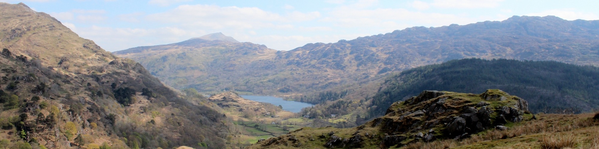
From the high point of the route, follow the path down and through an open area. There are a couple of ladder styles to negotiate and the first of the these is quite tricky for dogs as the drop on the far side is significant. As you progress downwards, there are amazing views of the mountains and Nant Gwynant (see large photo below). Eventually, you will come to the Watkin Path and enjoy the views of the dramatic waterfalls beyond.
The trail from Bylchau Terfyn to the falls is largely gravel but there are a few boggy portions in the high meadows. You may encounter livestock at any point and so dogs should be kept under control or on leads.
The Watkin Path and the Falls
You should stay on the trail from Bylchau Terfyn until it intersects with the Watkin Path and then turn right. The Watkin Path is one of the seven routes to the summit of Snowdon, but you will be heading downwards! If you have the time, take a short diversion to the falls before descending. There are numerous amazing spots for a picnic by the falls. The waterfalls cascade into deep pools in which you can swim if you don’t mind the chilly water!
After a break by the water, continue down the Watkin Path until you reach the main road. Turn right, cross the road and walk for a short distance until you come to a side road. Turn left here and follow the track past a farm and on to Llyn Dinas.
")
")
Llyn Dinas
After you have passed the farm, the trail takes you to the lake and then clings to the shore until you reach a gate on the far side, beyond which you will see a signpost for the trail to Beddgelert. Llyn Dinas is simply stunning and it is worth taking advantage of one of the many benches adjacent to the path which provide the perfect places to sit and soak in the serenity.
At the far end of the lake, there are two small beaches where dogs can paddle or take a swim before you complete your journey. When you are ready, pass through the gate and follow the path towards Beddgelert. After a short distance and just before the Sygun Copper Mine, a bridge enables you to cross the river, join the main road and return to the Craflwyn car park. Alternatively, extend your day by strolling down to Beddgelert.

Directions
From the Woollen Mill, Drive to Penygroes and then turn right at the COOP store. Turn right at the next T Junction and then right again at the next T Junction. Follow this road past Nantlle and up into the mountains. You will eventually arrive at the Village of Rhyd DDu where you should turn right towards Beddgelert. When you arrive in Beddgelert, follow the road through the village and go straight on at the bridge. Continue on this road for roughly a mile and you will see the entrance to the Craflwyn car park on the left.