
BYLCHAU TERFYN
Mountain walk of great diversity
Beginning from the National Trust’s Craflwyn car park, this is a moderately strenuous walk which takes you through diverse terrain. Woodland paths and waterfalls soon give way to open countryside before you ascend via a picturesque valley to Bylchau Terfyn. Here you have the option to continue on and down to Llyn Dinas via Cwm LLan and the lower portion of the Watkin Path or to retrace your steps back to Crafwyn. If you walk down to LLyn Dinas you can follow the trail around the lake and then return to Craflwyn via the road (A498) to create a circular route.
The first time we walked to Bylchau Terfyn, we retraced our steps and this is the walk that is explained here. If you are looking for a day out that gives you a bit of everything, this is the hike for you. Featuring ancient woodland, gorgeous waterfalls, rugged mountain terrain and an abandoned copper mine, the trail keeps you interested throughout your journey. The ascent isn’t overly challenging and your main problem will be keeping on track as this route is not well-marked.
Duration: 3.5 hours from the car park to the summit and back with a stop for lunch
Terrain: Woodland paths, rocky paths, some boggy areas

Getting Started
The trail starts behind the National Trust car park at Craflwyn and next to the information board which features surprisingly little information! One of the useful things that you won’t find here is a map of this route! To start with, follow the pink waymarkers for the Legendary Trail of Dinas Emrys. This trail will take you through woodland and past a small waterfall beside which there are stone steps leading up to gate. Keep following this route and you will arrive at a second waterfall which cascades into a pretty pool. It’s worth lingering here for a while as it is such a lovely spot. If you have the time, clamber up the hill next to the falls to see a gorgeous series of cascades tumbling down the mountainside.
Continue past the waterfall and around the corner. You will come to a point where the trail splits. The right hand fork is the Legendary Trail of Dinas Emrys. Ignore this and take the left fork which leads up into open countryside via switchbacks.
")
")
Getting Higher
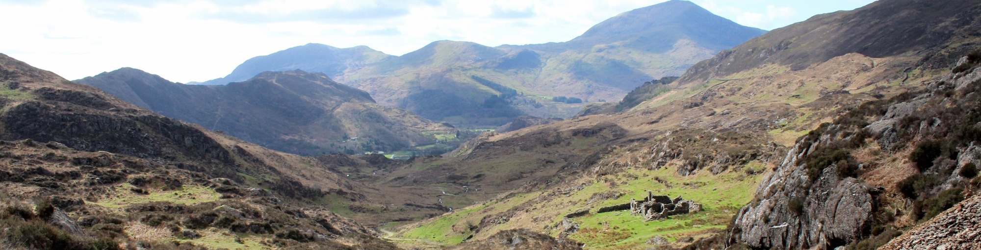
The trail climbs steadily upwards and it won’t be long before you start to benefit from wonderful views of the valley and surrounding peaks. Unfortunately this section of the route has no waymarkers but the path is pretty obvious, so you shouldn’t get lost. Watch out for a point by the river where the path splits again. Ignore the bridge over the river next to the derelict cottage and continue straight on through the metal gate. The path bends to left and you will see a small dam in the river. This is a nice spot for a rest and refreshments.
Continue on the trail which now does feature waymarkers. These have black arrows on white backgrounds. There are a few boggy areas to traverse and a couple of stiles. A little further on you will pass a disused copper mine which sits in an open area of the striking valley. The path then continues upwards and becomes a little steeper but nothing too challenging. If you are walking with dogs, please note that one of the stiles on this route has a dog hatch next to it, the other does not.
The High Point
Keep following the waymarkers with the black arrows. The last portion of the walk is the steepest and there are a few rocky sections which require a little clambering. But it only takes a few minutes to negotiate your way to the high point of the trail. Bylchau Terfyn delivers impressive views back down the valley and to the peaks beyond. It can get windy up there and so it isn’t the best place to stop for a picnic! If you would appreciate a rest, walk down a bit and find a nice spot to sit which is out of the breeze.
This the point at which you must decide whether to retrace your steps or continue to the lower portion of the Watkin Path and then back to the car park via LLyn Dinas. Either way, you will have a wonderful hike with stunning scenery and a variety of terrrain.
")
")
Walking Down
We found that it is only on the descent that you can fully appreciate the the beauty of the valley. On the way up, you have your back to the finest vistas but when you retrace your steps, you have a better opportunity to take it all in.
This walk is a great choice if you have dogs as there are plenty of open areas and streams to explore. There can be livestock about, so watch out for sheep if your pooch is likely to chase them! On the day we took the photographs you see here, we only encountered a couple of sheep but it was March when there doesn’t tend to be much livestock on the mountain.
This is a wonderful hike throughout the year and one which offers something interesting around every turn. Enjoy!

Directions
From the Woollen Mill, Drive to Penygroes and then turn right at the COOP store. Turn right at the next T Junction and then right again at the next T Junction. Follow this road past Nantlle and up into the mountains. You will eventually arrive at the Village of Rhyd DDu where you should turn right towards Beddgelert. When you arrive in Beddgelert, follow the road through the village and go straight on at the bridge. Continue on this road for roughly a mile and you will see the entrance to the Craflwyn car park on the left.