
SNOWDON RANGER PATH
Amazing views all the way!
The Snowdon Ranger Path is one of the easiest routes to the summit of Snowdon, the highest peak in England and Wales. The path is named after a mountain guide called John Morton who dubbed himself the ‘Snowdon Ranger’. He was responsible for building an Inn in the 19th century that was also known as the Snowdon Ranger. It was located where the Youth Hostel opposite the car park now stands. The walk begins from the car park on the A4085 that is situated on the shore of Llyn Cwellyn. It is a small car park that can fill up early during peak periods. You will pay £6 to park all day.
Although considered to be the second easiest route up Snowdon after the Llanberis Path, the Ranger Path remains a challenging walk, albeit one that most moderately fit people can manage. The first section of the walk is on gravel pathway and is easy going. Indeed, around 1km of the path is on level ground. It is the middle section of the route that presents the greatest challenge, as the track becomes rocky and climbs steeply upwards. But things level out as you near the railway track just below the summit and the final portion of the walk is straightforward. The total distance to the summit and back is 13km. The elevation gain is 3071 ft.
Please be aware that this isn’t an easy route up Snowdon, just a slightly less arduous one than most of the alternatives! It is important to acquaint yourself with the potential dangers. The weather on and around the mountain can change very quickly. To make matters worse, the conditions at the summit can be very different to those at the car park. It is entirely possible to set out on what appears to be the perfect day with sunshine and no wind, only to find yourself battling severe gales at higher elevations. Between October and April there may be snow and ice on the mountain, making the terrain treacherous. Always dress in layers and wear walking boots. Take plenty of food and water with you. If you walk up Snowdon between late September and early May, take a hat and gloves. Make sure you allow enough time to get up and down before darkness falls.
Over 700,000 people visit Snowdon each year. The mountain is an iconic tourist attraction and that can lull anyone into a false sense of security. It is all too easy to underestimate the challenge you face and the issues that could arise. Many people run into trouble on Snowdon. The Llanberis Mountain Rescue Team are typically called out around 200 times every year. A large proportion of these call outs concern incidents on Snowdon. On average, 8 people per year die on the mountain. Please don’t be one of them!
Duration: 5 – 6 hours from the car park to the summit and back.
Terrain: Gravel paths, rocky paths and stone steps.

Getting Started
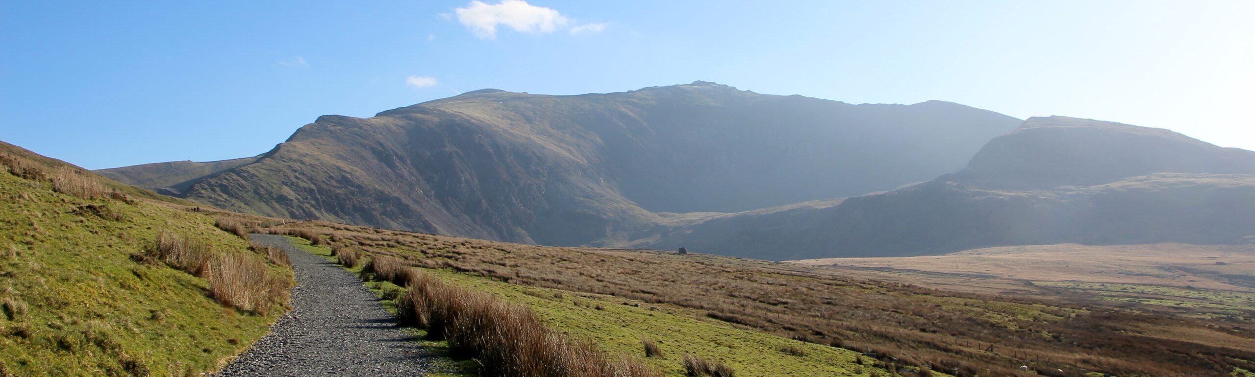
Exit the car park and cross the road. The start of the Ranger Path is a little to your right and is signposted. Walk up the path, then along the side of the railway track and through a gate. Cross the railway track and then head up past a farmhouse and onto a a gravel path. The path initially takes you upwards via a number of switchbacks but is easy going. After the switchbacks, there is a straight section of path that climbs relatively steeply. You begin to enjoy lovely views of Llyn Cwellyn below. On your return, you will be glad to end your walk on such a good surface and heading downwards! If you have a dog with you, it must be on a lead from the start of the walk as there will be plenty of sheep about.
")
")
The gravel path
After the straight, uphill section of the route, you will find yourself walking on a fairly long stretch of gravel path that is on level ground. You might begin to wonder if you are going to walk up a mountain at all. But you can see the summit of Snowdon above you and so you know that there must be a steep climb ahead and there is! Having said that, this path never becomes as steep and challenging as the Miner’s Track or the Pyg Track on the other side of the mountain. You will also find that the Ranger Path is much quieter than those routes which makes getting up and down much easier as you will rarely need to stand aside to let people past.
The steep bit!
Inevitably, there is a steep section of this walk to tackle. The gravel path disappears and the terrain under foot becomes rocky and uneven as you start to work you way up via a series of switchbacks. Happily this more taxing stage of the route isn’t overly long and comes with the bonus of increasingly impressive views of the lake beneath and the Nantlle Valley. Eventually you will emerge from the steep climb onto open hillside. The path still climbs relatively steeply but is much more even under foot and it doesn’t take long to reach the railway track. Just beyond the track, you will arrive at the point where the Ranger Path, Llanberis Path, Pyg Track and Miner’s Track all meet on the saddle just beneath the summit. This spot can be windy but does afford you your first views of the other side of the mountain.
")
")
The final ascent!
The final ascent to the summit is relatively easy unless there’s snow and ice on the ground, in which case it’s tricky! You approach the summit via a rocky path and stone steps. From the point where you cross the railway track, it only takes 10 minutes to the trig stone that marks the highest point on the mountain. It’s worth taking the time to admire the views in all directions. You can peer over the ridge to see Llyn Glaslyn and Llyn Lldaw far beneath you together with the Pyg Track and Miner’s Track. When you see how steep the ascent is on that side of the mountain, you might feel glad that you chose the Ranger Path. However, it has to be said that the views from the Miner’s Track are incredible!
At the summit
It is always a great feeling to reach the summit of any mountain but there’s something special about summiting Snowdon. However, that triumphal feeling can be somewhat diminished when you discover that hundreds of people are already there and you have to queue to get that all important photo at the trig stone. During peak times, Snowdon gets very busy indeed. This mountain is best walked late September to end October or mid-February to the first week of April, excluding the Easter holidays. Always check the weather forecast to ensure that the conditions enable you to complete the walk safely.
")

Directions
From The Woollen Mill, Drive to Penygroes and then turn right at the crossroads in front of the dog grooming parlour. Turn right at the next T Junction and then right again at the next T Junction. Follow this road past Nantlle and up into the mountains. You will eventually descend into the Village of Rhyd DDu and arrive at another T junction where you should turn left. Follow this road around the lake for around 1 mile and the car park will be on your left, opposite the youth hostel.