
SNOWDON PYG TRACK
Rewarding but challenging route
Introducing a beautiful walk with an ugly name! It isn’t possible to know for sure why the Pyg Track is so named. It could have been christened the Pyg Track to honour the pass it traverses, Bwlch y Moch, as this translates as “pig’s pass”. Alternatively, it could have acquired its name because the route was used to carry “pyg” (black tar) to the copper mines on the mountain.
The route climbs gradually from the car park and features rugged, rocky paths. The gradual ascent from the car park means you gain some altitude before you reach the point where the trail merges with the Miners’ Track. You will rise 2,372 feet by the time you reach the summit and the return journey is 11km long. Many walkers ascend via the Pyg Track and descend via the Miner’s Track which provides an easier route back to the car park. Both tracks begin at the Pen y Pass car park where spaces can be very hard to get.
It is important to remember that the weather on and around the mountain can change in minutes. To make matters worse, the conditions at the summit can be very different to those lower down. You could set out on what appears to be a calm and sunny day, only to find yourself battling severe gales at higher elevations. Between October and April, there could be snow and ice on the mountain, making the ground underfoot treacherous. Always dress in layers and wear walking boots. Take plenty of food and water with you. If you walk up Snowdon between late September and early May, you should also take a hat and a pair of gloves. Always ensure that you allow sufficient time to get up and down before darkness falls.
Over 700,000 people visit Snowdon every year. The mountain is a major tourist attraction and that might make you think that it isn’t much of a challenge. You would be wrong. Many people run into serious trouble on Snowdon. The Llanberis Mountain Rescue Team are typically called out around 200 times every year. A large proportion of the incidents they deal with occur on Snowdon. On average, 8 people per year die on the mountain. Around half of those come to grief on the Miners’ Track and Pyg Track.
The Pyg Track is a fabulous walk and not to be missed, if you are fit enough to complete it. But it’s pretty tough and hugely popular. Expect lengthy queues if you want to reach the summit of Snowdon during peak times, not to mention difficulty parking. Please read the directions at the bottom of this page for details of the parking options.
Duration: 6-7 hours from the car park to the summit and back.
Terrain: Rocky paths

Starting Out
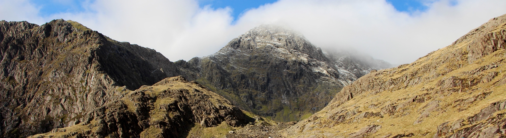
The walk begins from the Pen y Pass car park and is signposted. The terrain is rocky and uneven, almost from the start. Unlike the Miners’ Track which remains flat until shortly before it reaches the point below where it joins the Pyg Track, this route enables you to gain some altitude before you arrive at the beginning of the steep climb to to Bwlch Glas. That altitude gain makes the toughest portion of the walk slightly less demanding than it is when approached on the Miners’ Track. The Pyg Track works its way up from the car park towards LLanberis, giving you great views of the valley, before turning west and eventually emerging above Llyn Llydaw and Llyn Glaslyn. You can see the Miner’s track beneath you, once you are above the lakes, and the imposing west face of Snowdon rises up ahead of you. This portion of the walk isn’t particularly strenuous but the going under foot is rough and there are a few areas where you need to scrabble.
")
")
To the Miners’ Track
Continue following the rocky path and admiring the views until you reach the point where the Miner’s Track joins the Pyg Track. This is when you might be feeling a little smug that you have already gained some height before things get really steep. You will be able to see the serious ascent ahead of you and it does look rather intimidating. But don’t worry as there are plenty of spots where you can stop to take a breather on the way up. The meeting point of the two paths is marked by a stone and from there onwards you will find that the path gets busier as the hikers from the Miners’ Track are now sharing the same route up.
The climb to Bwlch Glas
You must now tackle the toughest portion of the walk. There’s no doubt about it, the climb to Bwlch Glas is tough. Bwlch Glas is the saddle that sits between the Pyg Track and the summit. It’s steep and the going under foot gets even harder than what you have experienced to that point. It is best to climb slowly and steadily, taking care not to trip or fall. This is an accident blackspot and there is no point in rushing things, as you will only increase your chances of coming to grief. The ascent is challenging but because of this, the distance you have to cover is relatively short. The summit will be visible above you throughout the climb and should provide the encouragement you need to carry on.
")
")
Bwlch Glas
After a steep climb, you will be relieved to arrive at Bwlch Glas. This is the point where the Pyg Track, Llanberis Path and Ranger Path all meet. There are stunning views over the Nantlle Valley to the coast and you can see Llyn Cwellyn, Beddgelert Forest and Moel Hebog. You may experience high winds on the saddle, even when conditions have felt calm elsewhere on the mountain. This area can also be quite treacherous when there is snow on the mountain as the grassy terrain turns to sheet ice. Take a few minutes to soak in the views here before tackling the final ascent to the summit of Snowdon.
Summiting and the return
From Bwlch Glas, the final ascent to the summit is relatively easy and takes only 10 minutes. The route up is clear and the going reasonable under foot. Follow the track to just below the trig stone and then you may have to queue to get your photograph at the summit. The wait for the summit can be up to 45 minutes on clear days in the Summer. Off peak, you might not have to wait for more than a couple of minutes.
After enjoying your moment of triumph, walk back down to Bwlch Glas and then retrace your steps until you meet the point where the Miners’ Track and Pyg Track meet. You can then decide which route you would like to take back to the car park. The Miners’ Track is certainly kinder under foot which could be a relief and the walk around the lakes is lovely on that trail.
")

Directions
From the Woollen Mill, drive to Penygroes and then turn right at the crossroads with the white dog grooming parlour on the corner. Turn right at the next T Junction and then right again at the next T Junction. Follow this road past Nantlle and up into the mountains. You will eventually arrive at the Village of Rhyd Ddu where you should turn right towards Beddgelert. When you arrive in Beddgelert, drive straight on at the stone bridge. Follow this road past Llyn Dinas and Llyn Gwynant until you reach the junction with the A4086. Turn left here towards Llanberis. The Pen y Pass car park will be on your left after a few hundred yards.
The Pen y Pass car park is quite small. It is necessary to book your space in advance during the the summer months. The rest of the year, at weekends and when the weather is good, the car park can still be full very early in the morning and you can’t book a space in advance. If the car park is full, you have three options. You can drive back towards Beddgelert and just after you turn right onto the A498, there are laybys on both sides of the road where you can park. The charge is £4 and there’s a footpath to Pen y Pass. Parking here will add 3km to your walk. Alternatively, head towards Llanberis and park in the Nant Peris car park just before the town or in Llanberis opposite the Snowdon railway station. There’s a Sherpa bus service from both car parks.