
CNICHT
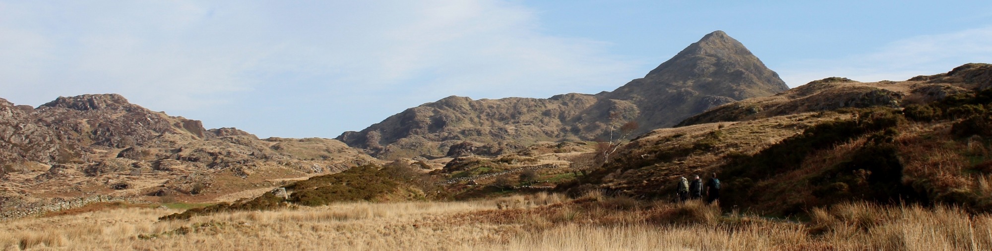
Cnicht from Croesor
Known as the Welsh Matterhorn due to its distinctive shape, Cnicht is a 689m peak and the fifth highest in the Moelwynion mountain range. The summit can be reached via a well marked trail which begins in the village of Croesor. There is a longer trail from Nantgwynant which is also worth exploring. Cnicht can’t rival the Matterhorn for height but it is a spectacular sight nonetheless and one of the more popular peaks to tackle in Snowdonia.
In case you were wondering, Cnicht is pronounced ker-nicht and the name is derived from the Old English word for Knight. The mountain was thought to resemble a knight’s helmet, although I don’t see it myself! The walk up is moderately challenging and does involve a little scrambling but most hikers won’t have any trouble reaching the summit. You can take your dog but some pooches will struggle with the final ascent which is quite dangerous as there are steep drops from the narrow trail.
Duration: 3 hours from the car park to the summit and back.
Terrain: gravel paths, grass, rocky trails and some scrambling.

Starting Out
The trail begins in the tiny and remote village of Croesor where you can park in the Snowdonia National Park Car Park which is free of charge. However, there aren’t many spaces and Cnicht is a popular walk. It is worth arriving early to avoid disappointment.
From the car park, walk through the village and past the school. There’s an unusual outdoor swimming pool built from slate which is on your left just after you leave the car park. Once you leave the village, the trail heads up into open countryside. You will soon reach a marker directing you to the right and onto heathland.
The walk is fairly easy going until you pass over a stile or through the adjacent gate and work your way up to a rocky ridge where the path gets steeper. There are a few places where you need to scrabble up rocks and the trail can be very uneven under foot. The path, such as it is, continues to steepen until you reach a flat grassy area immediately before the final ascent to the summit. This is an excellent place to stop for refreshments and a breather before the final push.
")
")
The final ascent
From the flat grassy area previously mentioned, it is only a 10 minute walk/scramble to the summit from where there are panoramic views of the mountains and valleys. You will feel like you are on top of the world, even though you are only 689 metres above sea level!
Please note that the summit of Cnicht is very exposed and prone to high winds. Check the weather before setting out because if there is any wind in the area, it will be at its worst around this peak.
You can now descend the way you came up or pass over the summit and down the other side, continuing to the valley and then returning to Croesor via a circular route. We descended the way we walked up but will try the circular walk at some point. It would be impossible to tire of the views from this mountain.
All the way to the sea
On the way back down the mountain, do stop to take in the views. You can see all the way to Porthmadog and the Ceredigion Bay on a clear day.
When you arrive back in Croesor, there is a small cafe but it only seems to open at peak times. You can take advantage of a bench in the car park next to the river if you would like to soak in the wonderfully peaceful setting.
It shouldn’t take you all day to tackle Cnicht and there are plenty of things to do close by including touring the gardens of Plas Brondanw which were landscaped by Clough Williams-Ellis, the architect who created Portmeirion.
")

Directions
Take the A487 towards Porthmadog. At the roundabout just before Porthmadog, turn left towards Tremadog and keep on this road until you see a left turn signposted for Rhyd. Take this road and then turn left towards Nantmor and soon after, right towards Croesor. Turn left into the village and the free Snowdonia National Park Car Park is on the right. There’s a portaloo in the car park.