
Cader Idris via the Minffordd Path
At 893 m (2,930 ft), Cader Idris is the highest mountain in southern Snowdonia and is a popular peak to tackle. While the summit of Cader Idris is much lower than that of Snowdon, don’t be fooled! The walk to the summit via the Minffordd path is tough! Indeed, this walk is considerably more challenging than any route up Snowdon with the possible exception of the Watkin Path.
This peak is named after a giant called Idris. Cader Idris means “Chair of Idris” and legend has it that Idris used the summit as a chair to survey his kingdom. The mountain is at the heart of many local myths and legends. It is said that if you spend the night on Cader Idris, you’ll end up either mad or a poet! If you are more interested in reality than mythology, the eastern slopes of the mountain provide excellent viewing points for fans of the Mach Loop, a low flying aircraft practice area.
The Minffordd Path begins at the Dôl Idris car park which is located just off the A487 at Minffordd which is 10 minutes south of Dolgellau. There are toilets in the car park and the parking area is generous in size but does fill up early at peak times. There is a charge for parking and the parking machines take coins or card payments.
Duration: 5-7 hours from the car park to the summit and back.
Terrain: stone steps, gravel paths and rocky scrabbles

Starting Out
Walk through the gate at the end of the car park near the toilets and then turn right and follow the signs for Cader Idris. You will pass the tea room and visitor centre before climbing steeply via stone steps. The path continues steeply upwards and you eventually find yourself alongside a river that is tumbling down the hillside. It has to be said that this is a tough start to a hard walk. Eventually, you will reach a fork in the path where you should keep left. The next section of the route provides a pleasing break from the steep ascent and takes you to an open area beneath the high peaks. You can enjoy the dramatic views of Craig Cau and the summit of Cader Idris as you walk along a gravel path that provides reasonable going under foot.
")
")
The easy bit!
You should enjoy the relatively easy walk towards Llyn Cau. The path is pleasant to walk on and the ascent is gradual until you reach the lake. However, the summits of Craig Cau and Cader Idris rise up above you and so you will be in no doubt about the nature of the challenge ahead! Follow the path until you come across another fork in the way. It is worth taking the right fork to make the short detour to Llyn Cau where you can enjoy a breather and refreshments before continuing upwards. But if you wish to head straight for the summit of the mountain, take the left fork.
Llyn Cau and beyond
According to local folklore, Llyn Cau is a bottomless lake. It isn’t, of course, but it is a striking mountain lake with Craig Cau providing an imposing backdrop. You can soak in amazing views of the lake as you continue on the Minffordd Path which now starts to rise steeply again. Follow the path upwards until you reach the ridge where, on a nice day, there are spectacular views down to mid Wales. When you arrive at the ridge, you are roughly half way to the summit of Cader Iris. You will find that the path becomes increasingly steep and uneven as you continue along the ridge and up towards the summit of Craig Cau. The Minffordd Path is unusual in that you will summit not one but two peaks. The final approach to Craig Cau is rough under foot and includes an eroded scree slope. There’s a style to tackle just before the summit. If you have your dog with you, look out for a large gap under the fence to the left of the style which your dog can use.
")
")
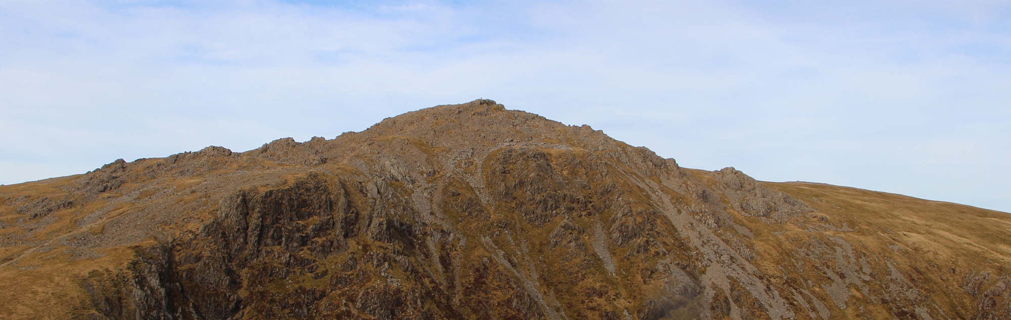
The final ascent
By the time you have reached the summit of Craig Cau, you will probably be feeling quite tired. Unfortunately, you need to descend a little before tackling the final ascent to the summit of Cader Idris and this can feel a little deflating after the challenges of the walk to Craig Cau. Take the rocky trail downwards and then upwards once more. Open grassy areas give way to yet more rocky terrain as you head upwards to your final destination. By this time you might well be asking yourself why you wanted to walk Cader Idris but it won’t be long before you reach the top and admire the incredible views in every direction. Don’t forget to admire the steep drops to the lake along the way (see photograph above).
At the summit and the descent
You will doubtless feel both relief and elation when you reach the summit! It’s worth taking a selfie or getting someone else to snap you at the trig stone to record your moment of triumph! There are wonderful views from the summit over the Mawddach Estuary to Barmouth and, to the north, you will see Coed y Brenin Forest Park. Once you have soaked in the vistas and caught your breath, you can retrace your steps down the mountain. As you can imagine, the descent will take a toll on on your knees and the rough ground makes walking down almost as tough as walking up. Take care throughout your descent as it is easy to trip on the scree slopes and rocky terrain, not to mention the stone steps.
")

Directions
Take the A487 south towards Porthmadog. Drive past Porthmadog and continue until you reach a roundabout where you turn left towards Penrhyndeudraeth. Continue on this road past Trawsfynydd and then past Dolgellau. Turn right towards Macynlleth at the Cross Foxes Inn and continue until you see the Gwesty Minffordd Hotel on your right. Take the next road on the right and park in the Dôl Idris car park.